Geo Art
General Information
The Ridgecrest area is home to 6 works of Geo Art totalling 245 caches. Within a 100 mile radius there are at least 17 more bringing the total to at least 23 works of Geo Art totalling over 1,600 caches!
Below you will find all the info you need to grab those smileys while visiting our local area including a list of the caches and pocket queries of each trail. If you see a series NOT listed, please let me know and I will add them ASAP.
Please double check the conditions of each cache before attempting a search as some may become archived or go missing after this list was created. I will only remove a series when the entire series has been archived. I have included archived caches in the pictures because in many cases, it wouldn't look the same with empty holes. You can click on the image of the art to enlarge it to see the details better.
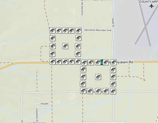
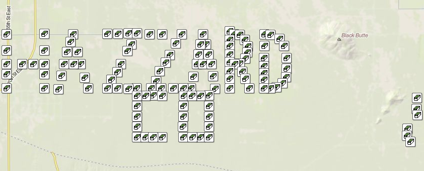
Spaded
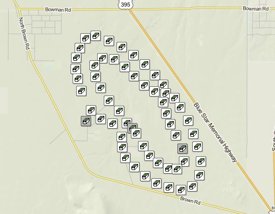
The Spaded Geo Art was the very first geo art in the area and were arranged and hidden to form an aerial spade.
It was created in April 2011 by nickandbeth2010. It was later adopted out to WeikHikes in July 2014. Difficulty ratings range from a 1.0 to a 2.0 and Terrain ratings range from 2.0 to 2.5. There orginally were 59 Traditional caches but 3 have since been permanently archived for a current total of 56 caches. There is NO bonus cache.
This is NOT a 'floatable' series. Please do not move/alter any of the geocaches. We hope you enjoy your day exploring and caching in the Mojave Desert, and always remember to tread lightly. 85% of this series may be accessed with a short walk off of existing dirt roads, the other 15% will require additional hiking. There is A LOT of soft sand in this area, a 4x4 is recommended.
Spaded Bookmark List | Back to Top | Spaded Series Pocket Query
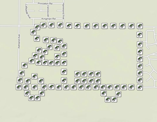
Signal
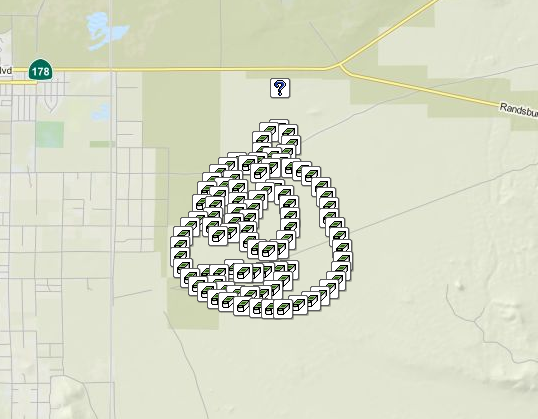
The Signal Geo Art caches were arranged and hidden to form the head of Signal, the Geocaching mascot.
It was created in November 2011 by White_Buffalo. Difficulty ratings are a 1.5 and Terrain ratings range from 1.5 to 2.0. There are 93 Traditional caches and 1 Mystery bonus cache for a total of 94 caches.
You can complete this one in sections, there is the Antenna section, Eyes section, Mouth section and Head section.
Signal Bookmark List | Back to Top | Signal Series Pocket Query
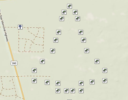
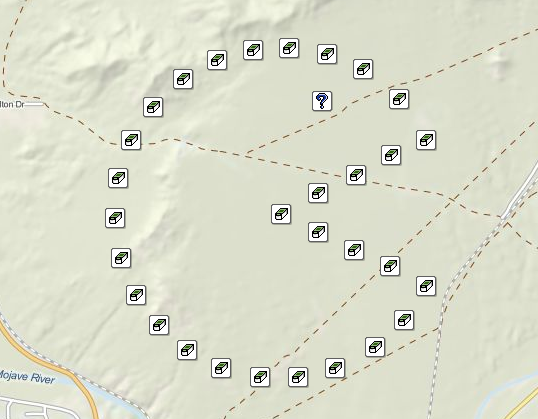
Is it a Bear or a Dipper?
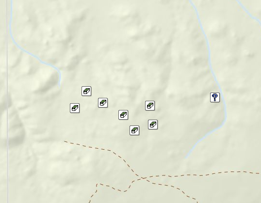
The Is it a Bear or a Dipper? Geo Art caches were arranged and hidden to form the The Big Dipper constellation. Each cache is named after one of the stars in the constellation.
It was created in February 2012 by Wii3B Family. It was later adopted out to MojaveDiva in June 2015. Difficulty ratings range from 2.5 to 3.0 and Terrain ratings range from 2.0 to 4.0. There are 7 Traditional caches and 1 Mystery bonus cache for a total of 8 caches.
Use high clearance vehicles and be sure to write the clues down in order to find the final star.
Is it a Bear or a Dipper Bookmark List | Back to Top | Is it a Bear or a Dipper Series Pocket Query
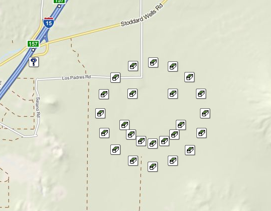
Geo Symbol
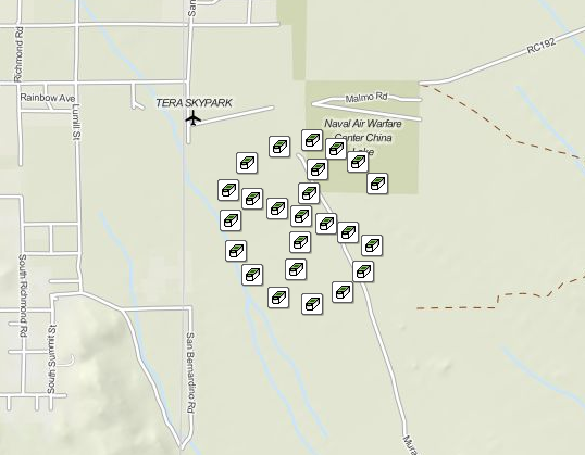
The Geo Symbol Geo Art caches were arranged and hidden to form the X Marks the Spot Geo Symbol.
It was created in April 2012 by MojaveDiva. Difficulty ratings is 1.5 and Terrain ratings range from 1.5 to 4.0. There are 24 Traditional caches and 1 Mystery bonus cache for a total of 25 caches.
It is best to hike this series. Park just off the road between 1 and 24. Please do NOT drive through the open desert. BLM will make us remove caches if this practice continues. Stay on posted roads.
Geo Symbol Bookmark List | Back to Top | Geo Symbol Pocket Query
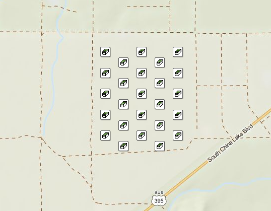
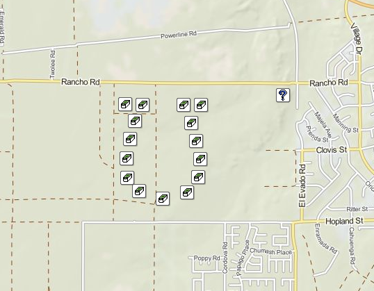
Dice
The Dice Geo Art caches were arranged and hidden to form a pair of dice. It is located in Inyokern.
It was created in March 2013 by catsimmie. Difficulty rating is 1.5 and Terrain rating is 1.5. There are 34 Traditional caches and NO bonus cache for a total of 34 caches.
This geo art was created in honor of the 2013 Ridgecrest Wildflower Festival. This area is prone to various wildlife and other assorted desert creatures. Remember, you are invading they're habitat! Please be considerate. I designed most of this series to be done by driving on roads and marked paths. DO NOT drive on unmarked areas. The 2 Snake Eyes caches MUST BE walked to. Do NOT attempt to drive to them as the road is unpassale in some areas even with 4x4's.
Dice Bookmark List | Back to Top | Dice Pocket Query
Gridlocked
The Gridlocked Geo Art caches were arranged and hidden to form a traffic jam on a major highway.
It was created in April 2013 by Eaglesong. It was later adopted out to MojaveDiva in May 2016. Difficulty rating is 1.0 and Terrain rating is 1.5. There are 25 Traditional caches and NO bonus cache for a total of 25 caches.
Each cache represents and gives facts on roads you really don't want to travel. There is parking all around and is friendly to two and four legged cachers.
Gridlocked Bookmark List | Back to Top | Gridlocked Pocket Query
Other Areas Geo Art
Within a 100 mile radius there are at least 17 more works of Geo Art adding an additional more than 1,400 caches!
Below you will find all the info you need to grab those smileys while visiting our local area including a list of the caches and pocket queries of each trail. If you see a series NOT listed, please let me know and I will add them ASAP. The caches are listed in order of closest to farthest from Ridgecrest.
Please double check the conditions of each cache before attempting a search as some may become archived or go missing after this list was created. I will only remove a series when the entire series has been archived.
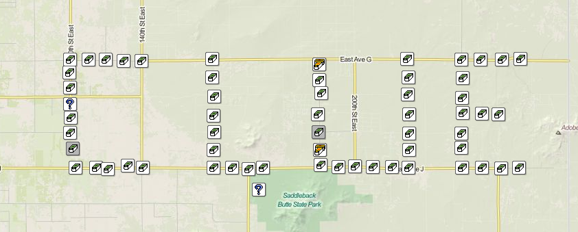
US Marine Corp Symbol
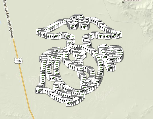
The US Marine Corp Symbol Geo Art caches were arranged and hidden to form a traffic jam on a major highway.
It's located 33 miles south of Ridgecrest located off the 395 towards Kramer Junction and was created in November 2013 by Team Stevecat. Difficulty ratings range between 1.0 to 2.0 and Terrain rating is 2.0. There are 401 traditional pill bottle caches, 20 traditional ammo can caches and NO bonus cache for a total of 421 caches.
Every page in the USMC series is unique revealing a piece of information about the United States Marine Corp. On these pages you'll read some of the interesting history from its people, bases and battles. We would love to hear about your adventures and see your photos. Please share them with us on USMC-1-Revolutionary War, GC4EXPT. This is a hiking series. There are dirt roads/washes that will get you close. Thanks and Enjoy.
US Marine Corp Symbol Bookmark List | Back to Top | US Marine Corp Symbol Pocket Query
Cactus
The Cactus Geo Art caches were arranged and hidden to form a traditional looking catus (not the kind found locally).
It's located 38 miles north of Ridgecrest located off the 395 towards Little Lake and was created in January 2014 by Umbra Scit. Difficulty ratings range between 1.5 to 2.5 and Terrain ratings range between 1.5 to 3.0. There are 37 traditional caches and NO bonus cache for a total of 37 caches.
It is a Premium Memers Only Geo Art and every cache in the series is named after a species of cacti and gives facts about it. This series requires a minimum 4.25 mile trek to visit all 37 caches in rather remote area with no cell-phone service available. Remember, this is a desert, bring plenty of water and be aware of your surroundings—there are things that can hurt you whether animal, vegetable, or mineral. Have Fun. Be Safe. Respect the environment.
Cactus Bookmark List | Back to Top | Cactus Pocket Query
Peace
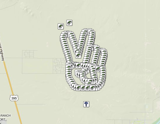
The Peace Geo Art caches were arranged and hidden to form a hand giving the Peace sign.
It's located 57 miles southeast of Ridgecrest located off the 395 towards Kramer Junction and was created in January 2013 by HDGC. Difficulty ratings range between 1.5 to 2.0 and Terrain ratings range between 1.5 to 2.0. There are 146 traditional caches and 1 bonus mystery cache for a total of 147 caches.
Peace! The V sign is a hand gesture in which the index and middle fingers are raised and parted, while the other fingers are clenched. It has various meanings, depending on the cultural context and how it is presented. It is most commonly used to represent the letter "V" as in "victory"; as a symbol of peace (usually with palm outward); and to represent the number 2. It was adopted by the 1960s counterculture movement as a sign for peace, which is what we are promoting. We encourage all geocachers to "Tread Lightly" (visit treadlightly.org or click the Tread Lightly logo below) when grabbing these caches. Please keep vehicles on the established trails and trek to the caches that don't have trails near them. And, please be sure to watch out for the critters that call this area home...remember, you are the visitor! We have trekked by many tortoise burrows, please be aware of them. To give you an idea, it took placing these caches a total of 10 hours. We left foot prints only. Tread Lightly....... On each listing there is a map of the trails that exist around the series shown in red. Most of these trails are 2WD safe but there are some areas where pin striping is unavoidable.
Peace Bookmark List | Back to Top | Peace Pocket Query
RV
The RV Geo Art caches were arranged and hidden to form a RV.
It's located 58 miles south of Ridgecrest located off the 395 towards Kramer Junction and was created in November 2012 by Mr-B. Difficulty ratings range between 1.5 to 2.5 and Terrain ratings range between 1.5 to 2.0. There are 81 traditional caches and NO bonus cache for a total of 81 caches.
Just adding a little artwork to the Planes, Trains & Automobile series with my own favorite type of vehicle, The RV. The caches along the outside border are on dirt roads that should be drivable by most vehicles. There are many roads that crisscross the middle, but I would recommend a high lift, or 4 wheel drive. There is a handful that you'll just have to walk to, but you can park in areas to make your hike shorter. No cross country vehicle travel is allowed in this area. There are a variety of difficulty levels from 1.5 to 2.5. And a variety of containers, please do not move containers - each is unique to that location.
RV Bookmark List | Back to Top | RV Pocket Query
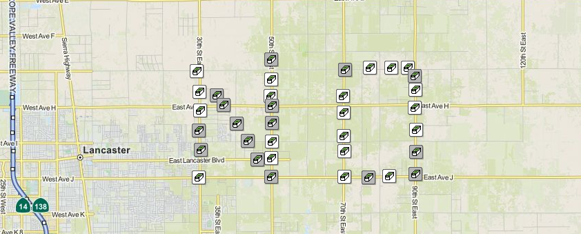
Get a Clue
The Get a Clue Geo Text caches were arranged and hidden to spelll the word Clue.
It's located 63 miles south of Ridgecrest located off the 14 in Lancaster and was created in January 2009 by Rallye. Difficulty ratings range between 1.5 to 3.0 and Terrain rating is 1.5. There orginally were 54 Traditional caches and 1 bonus mystery cache but 2 have since been permanently archived for a current total of 53 caches.
This Geo Text was created based on the board game Clue. After a by invite only party at a millionaires estate the owner of the estates body has been found. There is no doubt about it foul play has been involved. Being the lead Detective on call that night the task has fallen to you. After interviewing the estate staff you have come up with a few lists. There are 9 different places on this estate where the crime may have happened. The Dining Room, the Spa, on the Patio, in the Guest House, in the Living Room, in the Theater, in the Kitchen, in the Hall or in the Observatory. You have a list of 9 possible weapons. A Pistol missing from the nightstand, a piece of Rope from the velvet curtains, a silver Candlestick, a polo championship trophy that use to sit on the piano, a box of Poison that is missing from the gardeners shed, a baseball Bat signed by Hank Aaron, a Dumbbell that is missing from the gym, a knife missing from the kitchen and an Axe that use to be on the woodpile out back. You have your list of suspects that were at the party last night Miss Scarlet, Mr. Green, Mr. Mustard, Miss White, Mr. Plum, and Miss Peacock. This adds up to 486 different possibilities you will have to track down. At each of the caches that use an Ammo Can as the cache you will find a clue that either clears a room as the possible crime scene or find one of the missing weapons or be able to clear a suspect by their alibi. Once you have deduced what is NOT you will be left with the WHO, WHAT and WHERE of this hideous crime.
Get a Clue Bookmark List | Back to Top | Get a Clue Pocket Query
Space Shuttle
The Space Shuttle Geo Art caches were arranged and hidden to form a Space Shuttle.
It's located 65 miles south of Ridgecrest located off the 395 in Adelanto and was created in December 2011 by AndrewOlvera. Difficulty ratings range between 2.0 to 4.0 and Terrain ratings range between 2.0 to 3.5. There are 26 traditional caches and 1 mystery bonus cache for a total of 27 caches.
Each cache is named after a fact about space travel and the listing gives more information on that fact.
Space Shuttle Bookmark List | Back to Top | Space Shuttle Pocket Query
No
The No Geo Text caches were arranged and hidden to spelll the word No.
It's located 65 miles south of Ridgecrest located off the 14 in Lancaster and was created in February 2009 by ShowStop. Difficulty ratings range between 1.5 to 2.0 and Terrain ratings range between 1.5 to 2.0. There orginally were 36 Traditional caches but 16 have since been permanently archived for a current total of 20 caches. Some people have added caches to replace the archived ones, those are listed on the Bookmark Page
This geo art was placed next to the Get a Clue series when several of those caches were missing and the CO wasn't maintaining them. The two together spelled out No Clue! Now from what I've been told, both have a lot of replacement containers and many clues are missing for the final cache.
No Bookmark List | Back to Top | No Pocket Query
Cross
The Cross Geo Art caches were arranged and hidden to form a Space Shuttle.
It's located 67 miles south of Ridgecrest located off the 14 in Lancaster and was created in December 2011 by JimHaa. Difficulty rating is 2.0 and Terrain rating is 2.0. There are 30 traditional caches and No bonus cache for a total of 30 caches.
Each cache is named after a bible verse with the book name listed backwards.
Cross Bookmark List | Back to Top | Cross Pocket Query
Oz
The Oz Geo Text caches were arranged and hidden to spelll the word Oz.
It's located 71 miles southeast of Ridgecrest located off the 14 in Lancaster and was created in June 2012 by Team Stevecat. Difficulty rating is 2.0 and Terrain rating is 2.0. There orginally were 49 Traditional caches but 2 have since been permanently archived for a current total of 47.
This series is a tribute to The Wizard of Oz. Each name represents something from the movie (quote, actor, etc) and the listing includes a tidbit related to that. The combination of geo-art and cache-art make finding these not only challenging, but rewarding. To Oz?? To Oz!!
Oz Bookmark List | Back to Top | Oz Pocket Query
Groundspeak
The Groundspeak Geo Art caches were arranged and hidden to form the X Marks the Spot Geo Symbol.
It's located 75 miles southeast of Ridgecrest located off the 15 outside of Victorville and was created in February 2010 by HDGC. Difficulty ratings range between 1.5 to 2.0 and Terrain ratings range between 1.5 to 4.5. There are 41 traditional caches and 1 mystery bonus cache for a total of 42 caches.
Each cache represents something every Geocacher needs to do and the listing defines that. This Series has a little bit of everything ranging from 2-wheel drive, high-clearance, and some 4x4 access to a couple of smash and grab, some trekking, and a little hiking. You may encounter some pin striping if you choose a straight route. The hides and terrain are a mix of things. There are fenced areas that cannot be trespassed. You will find an area of posted signs warning you that there is an area to stay out of nearby. You will have access to the roads. If unsure, you can verify info with the "claim" located in containers near the claim. This Series was scouted and placed by the Scrabble Dogs and I in a total of 9 hours. This includes prepping, coordinate verifications, and taking in the views. What this means is that you will be able to accomplish this series in less time unless you prefer to take in the views and explore the area. You will find yourself in a secluded part of the desert. Bring some lunch and snacks, and most importantly, bring plenty of water, especially if you're here during the spring and summer months. You'll want to be prepared regardless of the conditions. Like always, never stick your hand in places you can't see as you will be in critter country. Please respect the Desert and stay on designated roads.
Groundspeak Bookmark List | Back to Top | Groundspeak Pocket Query
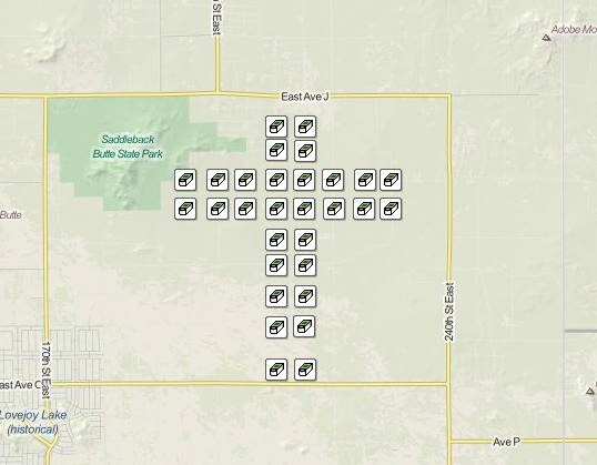
Hazzard Co
The Hazzard Co Geo Text caches were arranged and hidden to spelll the words Hazzard Co.
It's located 75 miles south of Ridgecrest located off the 14 in Lancaster and was created in March 2013 by JimHaa. Difficulty ratings range is 2.0 to 4.0 and Terrain ratings range is 2.0 to 3.0. There orginally were 121 traditional caches and 1 mystery cache for a current total of 122.
There are 122 total caches in this series dedicated to the 'Dukes of Hazzard' television series. Each cache name represents something having to do with The Dukes of Hazzard and the listing gives you tidbits on that. In 44 of the caches you will find Duke playing cards. Note the name and number on the card, as well as the number of cards for each name, and then use this information to find the HZ-Mystery Cache, containing an actual General Lee for the FTF. Yee-Haw!!!!!!
Oz Bookmark List | Back to Top | Oz Pocket Query
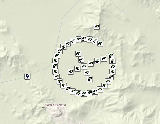
30 Yrs of Pacman
The 30 Yrs of Pacman Geo Art caches were arranged and hidden to form Pacman.
It's located 76 miles south of Ridgecrest located off the 15 outside of Victorville and was created in May 2010 by michaelamoody. Difficulty ratings range between 3.5 to 4.0 and Terrain ratings range between 3.5 to 2.5. There are 30 traditional caches and 1 mystery bonus cache for a total of 31 caches.
Pac-Man is an arcade game developed by Namco and licensed for distribution in the U.S. by Midway, first released in Japan on May 22, 1980. Immensely popular in the United States from its original release to the present day, Pac-Man is universally considered as one of the classics of the medium, virtually synonymous with video games, and an icon of the 1980s popular culture. Please dive on the trails. You are able to park within 800 feet of every cache. There are big trucks moving along quary road so look both was and stop at all crossings. The containers are all different sizes with different camo on each. Please hide all containers as good as they were found. If any maintance needs to be done to these caches let the CO know ASAP so he can get them up and running quickly.
Pacman Bookmark List | Back to Top | Pacman Pocket Query
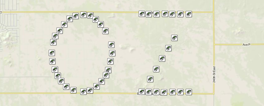
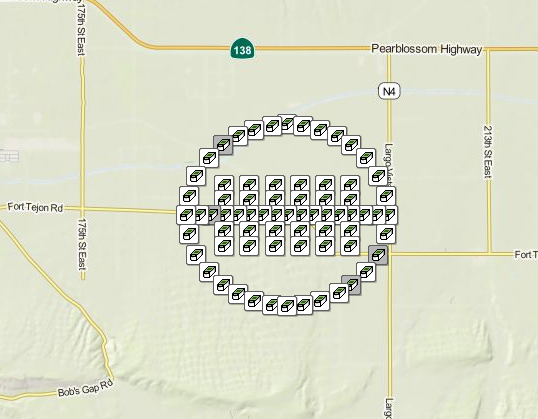
The Smiley Face
The The Smiley Face Geo Art caches were arranged and hidden to form a smiley face.
It's located 77 miles south of Ridgecrest located off the 15 outside of Victorville and was created in November 2008 by HDGC. Difficulty ratings range between 1.0 to 1.5 and Terrain rating is 1.5. There are 25 traditional caches and 1 mystery bonus cache for a total of 26 caches.
Have you ever wanted to see your Geo-Map full of smiley faces in the shape of a Big Smiley Face? Now you can! The series covers an area that is 1 mile in diameter and 3.14 miles in circumference. You can easily walk to each cache from existing roads and trails without damaging the fragile landscape.
Smiley Face Bookmark List | Back to Top | Smiley Face Pocket Query
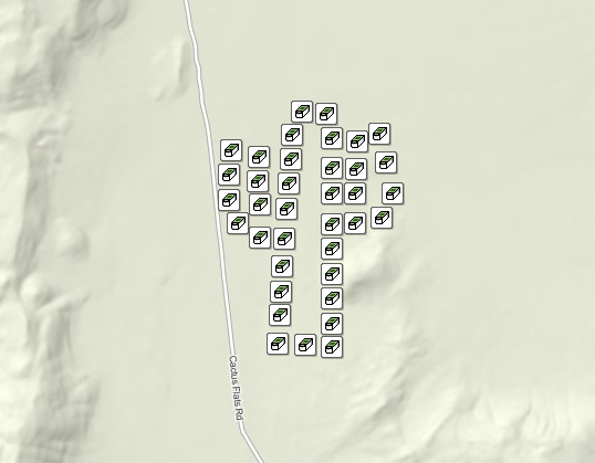
Lucky Horseshoe
The Lucky Horseshoe Geo Art caches were arranged and hidden to form a lucky horseshoe.
It's located 77 miles south of Ridgecrest located off the 395 in Adelanto and was created in January 2015 by priesterluck. Difficulty ratings range between 1.0 to 2.0 and Terrain rating is 2.0. There are 15 traditional caches and 1 mystery bonus cache for a total of 16 caches.
Important: To find the mystery cache you will have to write down the number that is written somewhere on the containers of each of the 15 traditional caches. In most cases, the number is on the inside of the lid. Then sequence those numbers according to the numerical order of each of the caches. For example, #1 of the series has the first number of the mystery coordinate, #2 of the series has the second number of the coordinate, and so on. Although you do not have to have four wheel drive to access the caches, take care in driving as some trails are better than others.
Lucky Horseshoe Bookmark List | Back to Top | Lucky Horseshoe Pocket Query
BR Plane
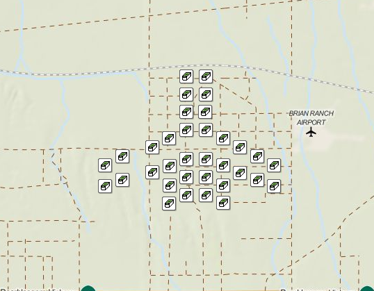
The BR Plane Geo Art caches were arranged and hidden to form an airplane.
It's located 78 miles south of Ridgecrest located off the 138 in Lancaster and was created in December 2013 by JimHaa. Difficulty ratings range between 1.5 to 2.0 and Terrain ratings range between 2.0 to 3.0. There are 34 traditional caches and No mystery bonus cache for a total of 34 caches.
This Geo Art is located near the Brian Ranch Airport. Each name represents something having to do with air travel.
BR Plane Bookmark List | Back to Top | BR Plane Pocket Query
Football
The Football Geo Art caches were arranged and hidden to form a football.
It's located 80 miles southeast of Ridgecrest located off the 138 in Lancaster and was created in January 2013 by JimHaa. Difficulty ratings range between 1.5 to 2.5 and Terrain ratings range between 1.5 to 3.0. There orginally were 71 Traditional caches but 4 have since been permanently archived for a current total of 67 caches. There is NO bonus cache.
This football geoart series can be enjoyed by all. Each cache represents a fictional NGFL (National Geocaching Football League) Team. I did not see one muggle in the three days it took me to create, which makes it a great series to relax and enjoy. Happy caching!
Football Bookmark List | Back to Top | Football Pocket Query
Route 66 Emblem
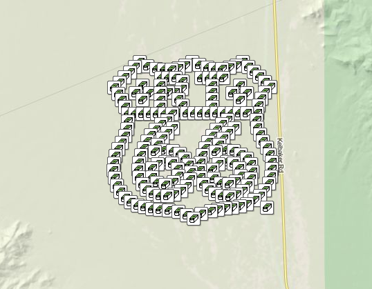
The Route 66 Emblem Geo Art caches were arranged and hidden to form the Route 66 Emblem. It is over 100 miles from Ridgecrest, but we've included it because the CO's Team Stevecat has done so much for our geocaching area and they're not even local! It's also part of their Route 66 Power Trail Series, so you can combine the two.
It's located 129 miles southeast of Ridgecrest located off the 40 outside of Amboy and was created in January 2013 by Team Stevecat. Difficulty rating is 1.5 and Terrain rating is 3.0. There are 200 traditional caches and NO bonus cache for a total of 200 caches.
Will Rogers Highway, Main Street of America, The Mother Road – whatever you call U.S. Route 66, the more than 2000 mile highway is the original home of the road trip. This series is dedicated to key landmarks along Historic Route 66. From The Windy City to the Pacific Coast, Route 66 is a wonderful way to explore America. The historic highway runs past once-forgotten monuments, oddball landmarks, awesome natural scenery and honest-to-goodness small town charm. For your caching pleasure, here are some landmarks to make the journey worthwhile! This is the California Desert and home to many animals. This is their home! Please take care of it while you are visiting. This artwork has 200 caches in it and is over 20 miles in total. There are 2 dirt access roads from the main highway. You can use these roads to get near major portions of the artwork. This is no place for motorhomes. The dirt roads are not friendly to low clearance vehicles. There are soft shoulders on Kelbaker Road and you may get stuck if not careful. We have placed 3 Ammo Cans with extra logs and containers throughout the trail for any caches that may need some TLC. Use them if needed and please deposit any extras when you leave so others may use them.
Route 66 Emblem Bookmark List | Back to Top | Route 66 Emblem Pocket Query